Grossglockner Pass / Edelweissspitze from Heiligenblut via Hochtor

Grossglockner Pass / Edelweissspitze from Heiligenblut via Hochtor is a climb in the region Carinthia. It is 26km long and bridges 1712 vertical meters with an average gradient of 6.6%, resulting in a difficulty score of 1618. The top of the ascent is located at 2538 meters above sea level. Climbfinder users shared 4 reviews of this climb and uploaded 22 photos.
Road name: 107
4.0 by GorgorbeyThis is an automatic translation, the original language is: Dutch.I know that every col everyone has a different experience with a climb. Depending on condition, weight, length, talent, and so on. And so I don't like it when someone wants to undermine someone else's experience. But after reading this review yesterday, I thought I was in for an easy cl... read more
Photos (22)


If you want to upload your photos, you need to create an account. It only takes 1 minute and it's completely free.
- Add photos of your conquered climbs.
- Share your experience on all ascents you've climbed
- Submit your favorite climbs
Statistics
| Grossglockner Pass / Edelweissspitze from Heiligenblut via Hochtor This climb |
Carinthia 120 climbs | Austrian Alps 633 climbs | Austria 917 climbs | Alps 4998 climbs | Europe 43819 climbs |
|---|---|---|---|---|---|
|
1618
|
rank
4
|
rank
7
|
rank
7
|
rank
28
|
rank
66
|
|
Average gradient
6.6%
|
rank
62
|
rank
394
|
rank
523
|
rank
2744
|
rank
11917
|
|
Length
26km
|
rank
2
|
rank
13
|
rank
13
|
rank
112
|
rank
361
|
|
Total ascent
1712m
|
rank
3
|
rank
5
|
rank
5
|
rank
33
|
rank
85
|
Classification
Road surface condition
Traffic
Climbing times
| 7 km/h | 03:42:43 |
| 11 km/h | 02:21:44 |
| 15 km/h | 01:43:56 |
| 19 km/h | 01:22:03 |
Popular


Reviews (4)

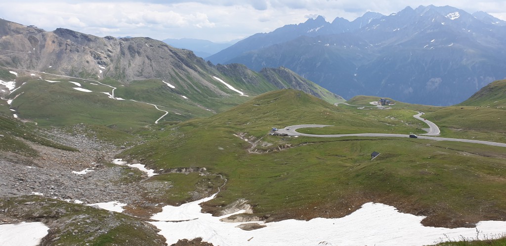
Started from Winklern at car park. From here rode along the main road to Döllach. Indeed, from Döllach you can ride somewhat parallel to the busy road. The climbing then starts immediately but I found it a more pleasant/quiet ride.
You then also arrive a bit higher in Heiligenblut. From there, you are close to the toll booths and it really keeps on climbing. Once at Hochtor, you can take beautiful photos and then drive there to the Edelweissspitze. From Hochtor, you still have to go through 2 tunnels before you can do the hugely congested climb to the Edelweissspitze. When I was there, there was a traffic jam with cars to get to the top. You can get through by bike, though.
Tip: there are not a huge number of restaurants, so bring plenty of food yourself.
Rear lights are a must in the tunnels.
Along the way, I came across in drinking water point anyway.
Vanuit Winklern gestart op parkeerplaats. Vanuit hier over de hoofdweg naar Döllach gereden. Vanuit Döllach kun je namelijk wat parallel aan de drukke weg rijden. Het klimmen begint dan wel direct maar vond ik prettiger/rustiger rijden.
Je komt dan ook iets hoger aan in Heiligenblut. Vanaf daar ben je dichtbij de tolpoortjes en blijft het echt flink klimmen. Eenmaal bij Hochtor kun je prachtige foto’s maken om vervolgens daar te rijden naar de Edelweissspitze. Je moet vanaf Hochtor nog door 2 tunnels voordat je de enorm drukke klim naar de Edelweissspitze kunt doen. Toen ik er was stond er een file met auto’s om boven te komen. Met de fiets kun je er wel doorheen komen.
Tip: er zijn niet enorm veel restaurants, dus neem zelf voldoende eten mee.
Achter-verlichting is wel een must in de tunnels.
Onderweg kwam ik sowieso in drinkwaterpunt tegen.


Beautiful climb which starts well before Heiligenblut. The climb goes over the GrossglocknerStrasse which is free for cyclists. The road can be very busy but my experience is that in Austria other road users take cyclists well into account. Tip: leave early. I rode it on my bicycle in somewhat grey weather and even had quite a few fellow road users. At the pass on the point of Hochtor (where a water tap and toilet etc. is located) you drive through a tunnel of a few hundred meters (make sure you have lights). This is followed by a smooth descent and a final climb to the highest point, the Eidelweisspitze. The last 1.5-2km is on cobblestones. On the summit and the descent it was very cold. I read from other cyclists that they had experienced hypothermia on that day (end of July). In the descent it started to rain, fortunately the road surface is mostly good. After descending to the roundabout, I went up the side of the KaiserFransJozef climb. It is then still about 8km climbing (with tough parts in between) to the viewpoint on the glacier of the GrossGlockner.
Prachtige beklimming welke ruim voor Heiligenblut begint. De klim gaat over de GrossglocknerStrasse welke voor fietsers gratis is. De weg kan erg druk zijn maar mijn ervaring is dat in Oostenrijk medeweggebruikers goed rekening houden met fietsers. Tip: vroeg vertrekken. Ik reed hem op de fiets in wat grijs weer en had zelfs best veel medeweggebruikers. Bij de pas op het punt van Hochtor (waar een watertappunt en wc ed. zit) rijd je door een tunnel van een paar honderd meter (zorg voor verlichting). Daarna volgt een prima lopende afdaling en een laatste klim naar het hoogste punt de Eidelweisspitze. De laatste 1,5-2km gaat over kasseien. Op de top en de afdaling was het erg koud. Ik las van andere fietsers dat ze op die dag (eind juli) onderkoelingsverschijnselen hadden gehad. In de afdaling ging het regenen, gelukkig is het wegdek overwegend goed. Na te zijn afgedaald tot de rotonde ben ik de kant van de KaiserFransJozef klim opgegaan. Het is dan nog zo'n 8km klimmen (met pittige stukken ertussen) naar het uitzichtpunt op de gletsjer van de GrossGlockner.

I know that every col everyone has a different experience with a climb. Depending on condition, weight, length, talent, and so on. And so I don't like it when someone wants to undermine someone else's experience.
But after reading this review yesterday, I thought I was in for an easy climb. That's how trivially the review above was written.
But what is written above 'Relatively easy climb' is 'quatsch' or 'zever in pakskes' as we say in Antwerp.
There is indeed a lot of traffic on this pass, that is correct. But this is not a relatively easy climb. The percentages in the profile here on climbfinder seem a bit low to me. This is without a doubt a tough climb. Dear fellow climbers, do not get caught by this. Soon after Heiligenblut you go to percentages towards 11% . Around the whole climb, except for a small descent before the summit, the percentages were around or above 10%, so if this climb is relatively easy you won't find any climb in the whole of France that is even a challenge... This is a killer climb. OK, it was 30 degrees when I did it, but a whole climb up to 10% you can feel it!
Oh yes, and on the other hand, it is just as hard, but even more beautiful!
Ik weet dat elke col iedereen een andere ervaring heeft met een beklimming heeft. Afhankelijk van conditie, gewicht, lengte, talent, enzovoort. En dus vind ik het ook niet leuk als iemand iemand anders ervaring onder uit wil halen.
Maar nadat ik gisteren deze review las, dacht ik dat ik een makkelijke klim tegemoet ging. Zo triviaal is de review hierboven geschreven.
Maar wat hierboven staat 'Relatief gemakkelijke klim is 'quatsch' of 'zever in pakskes' zoals we in Antwerpen zeggen.
Er zit inderdaad veel verkeer op deze pass, dat is correct. Maar dit is geen relatief gemakkelijk klim. De percentages in het profiel hier op climbfinder lijken me zelfs wat laag ingeschat. Dit is zonder twijfel een zware klim. Beste collega-klimmers laat u hieraan niet vangen. Vrij snel na Heiligenblut ga je naar percentages richting 11% . Om deze hele klim met uitzondering van een kleine afdaling voor de klim naar de top blijven de percentages stond rond en boven de 10%, dus als deze klim een relatief makkelijke klim is dan vind je in gans Frankrijk geen klim die ook maar een uitdaging vormt... Dit is een killerklim. OK, toen ik hem deed was het 30 graden, maar een ganse klim tegen de 10% die voel je!
Oh ja, en langs de andere kant is ie even zwaar, maar NOG mooier!