Category:Pfarrkirche Hengsberg
Jump to navigation
Jump to search
| Object location | | View all coordinates using: OpenStreetMap |
|---|
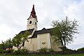
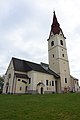
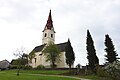
church building in Hengsberg, Austria   | |||||
| Upload media | |||||
| Instance of | |||||
|---|---|---|---|---|---|
| Location | Hengsberg, Leibnitz District, Styria, Austria | ||||
| Street address |
| ||||
| Heritage designation | |||||
 | |||||
Subcategories
This category has only the following subcategory.
P
Media in category "Pfarrkirche Hengsberg"
The following 10 files are in this category, out of 10 total.
-
 Hengsberg 294A5893 Steiermark.jpg 4,432 × 2,168; 1.81 MB
-
 Hengsberg pfk 005.jpg 2,304 × 3,072; 3.82 MB
-
 Pfarrkirche Heiliger Laurentius Hengsberg 01.jpg 4,000 × 6,000; 12.13 MB
-
 Pfarrkirche Heiliger Laurentius Hengsberg 02.jpg 6,000 × 4,000; 14.67 MB
-
 Pfarrkirche Heiliger Laurentius Hengsberg 03.jpg 4,000 × 6,000; 12.69 MB
-
 Pfarrkirche Heiliger Laurentius Hengsberg 04.jpg 6,000 × 4,000; 13.42 MB
-
 Pfarrkirche Heiliger Laurentius Hengsberg 05.jpg 6,000 × 4,000; 11.31 MB
-
 Pfarrkirche Heiliger Laurentius Hengsberg 06.jpg 4,000 × 6,000; 12.15 MB
-
 Pfarrkirche Heiliger Laurentius Hengsberg 07.jpg 6,000 × 4,000; 12.98 MB
-
 Pfarrkirche Hengsberg 20120510.jpg 2,448 × 3,264; 2.37 MB


