File:Neuhaus am Klausenbach - röm.-kath. Kirche.JPG
Jump to navigation
Jump to search

Size of this preview: 449 × 599 pixels. Other resolutions: 180 × 240 pixels | 360 × 480 pixels | 576 × 768 pixels | 768 × 1,024 pixels | 1,535 × 2,048 pixels | 2,950 × 3,935 pixels.
Original file (2,950 × 3,935 pixels, file size: 9.52 MB, MIME type: image/jpeg)
Captions
Captions
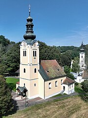
South view of the parish church of Saint Stephen in Neuhaus am Klausenbach.
Summary[edit]
| Description |
Deutsch: Südansicht der röm.-kath. Pfarrkirche hl. Stephan in der burgenländischen Marktgemeinde Neuhaus am Klausenbach und rechts hinten der Kirchturm der evangelischen Kirche.
Die Saalkirche mit eingezogenem Polygonalchor wurde im 17. Jahrhundert errichtet. Der vorgestellte Kirchturm im Süden wurde im 18. Jahrhundert mit einem weiteren Obergeschoß erhöht und mit einem Zwiebelhelm versehen. English: South view of the parish church of Saint Stephen in Neuhaus am Klausenbach. |
| Date | |
| Source | Own work |
| Author | C.Stadler/Bwag |
| Permission (Reusing this file) |
Deutsch: Hallo, du darfst mein Foto kostenlos nutzen, aber nenne mich bitte als Fotograf, beispielsweise „Foto: C.Stadler/Bwag“ oder © C.Stadler/Bwag; CC-BY-SA-4.0. Auf mehr Angaben bestehe ich nicht - im Gegensatz zu manch anderen, die die Vorgaben der unten angeführten Lizenzierung auf Punkt und Beistrich einfordern. English: Feel free to use my photos, but please mention me as the author like © C.Stadler/Bwag or © C.Stadler/Bwag; CC-BY-SA-4.0 (that's good enough) and if you want send me a message: bwag@gmx.net. |
| Object location | | View this and other nearby images on: OpenStreetMap |
|---|
| Camera location | | View this and other nearby images on: OpenStreetMap |
|---|
Licensing[edit]
I, the copyright holder of this work, hereby publish it under the following license:
This file is licensed under the Creative Commons Attribution-Share Alike 4.0 International license.
- You are free:
- to share – to copy, distribute and transmit the work
- to remix – to adapt the work
- Under the following conditions:
- attribution – You must give appropriate credit, provide a link to the license, and indicate if changes were made. You may do so in any reasonable manner, but not in any way that suggests the licensor endorses you or your use.
- share alike – If you remix, transform, or build upon the material, you must distribute your contributions under the same or compatible license as the original.
File history
Click on a date/time to view the file as it appeared at that time.
| Date/Time | Thumbnail | Dimensions | User | Comment | |
|---|---|---|---|---|---|
| current | 21:45, 17 September 2023 | | 2,950 × 3,935 (9.52 MB) | Bwag (talk | contribs) | wb |
| 21:33, 17 September 2023 |  | 2,950 × 3,935 (8.88 MB) | Bwag (talk | contribs) | == {{int:filedesc}} == {{Information |Description= {{de|1= Südansicht der röm.-kath. Pfarrkirche ''hl. Stephan'' in der burgenländischen Marktgemeinde Neuhaus am Klausenbach.<br/>Die Saalkirche mit eingezogenem Polygonalchor wurde im 17. Jahrhundert errichtet. Der vorgestellte Kirchturm im Süden wurde im 18. Jahrhundert mit einem weiteren Obergeschoß erhöht und mit einem Zwiebelhelm versehen.}} {{en|1= South view of the parish church of Saint Stephen in Neuhaus am Klausenbach.}} |Source= {{ow... |
You cannot overwrite this file.
File usage on Commons
The following 2 pages use this file:
File usage on other wikis
The following other wikis use this file:
- Usage on de.wikipedia.org
- Usage on www.wikidata.org