File:Völkermarkt - Burgruine Haimburg (b).JPG
Jump to navigation
Jump to search
Size of this preview: 800 × 533 pixels. Other resolutions: 320 × 213 pixels | 640 × 427 pixels | 1,024 × 683 pixels | 1,280 × 853 pixels | 2,560 × 1,706 pixels | 4,718 × 3,145 pixels.
Original file (4,718 × 3,145 pixels, file size: 9.89 MB, MIME type: image/jpeg)
Captions
Captions
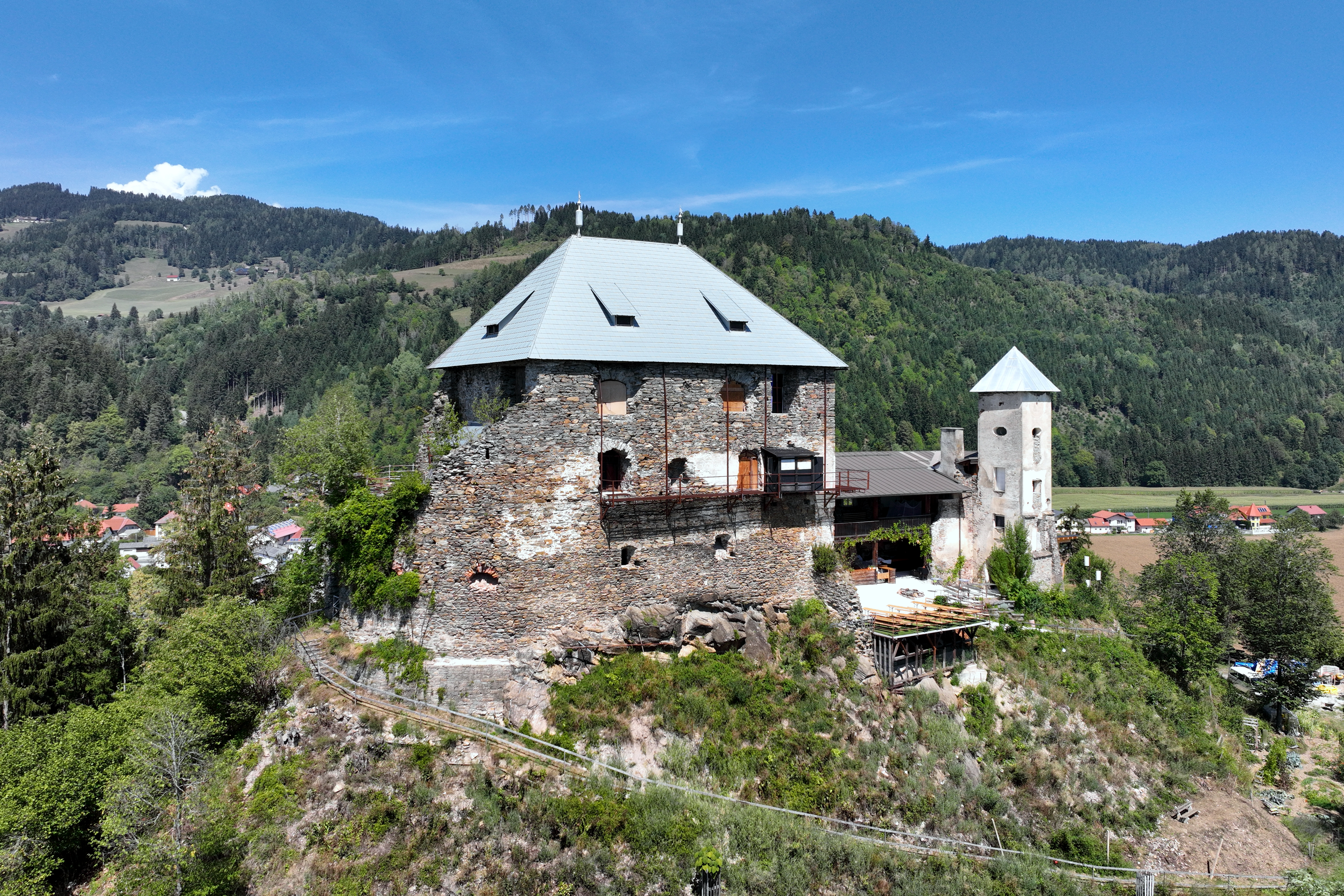
Southwest view of Haimburg Castle in Carinthia.
Summary[edit]
| Description |
Deutsch: Südwestansicht der Burgruine Haimburg, auch als Heunburg bezeichnet, in Haimburg, ein Ortsteil in der Kärntner Stadtgemeinde Völkermarkt.
Die auf einem weithin freistehenden Felskegel errichtete Burg wurde 1103 erstmals urkundlich erwähnt. Sie diente den Grafen von Heunburg bis 1228 als Stammsitz. 1886 erwarben die Freiherren von Helldorff die Anlage, in deren Besitz sie sich auch heute noch befindet. In Zusammenarbeit mit dem Verein „Rettet die Heunburg“, privaten Sponsoren und öffentlichen Stellen wurde die Ruine ab 1989 restauriert: [1]. Seit 1995 wird sie als Veranstaltungsort genutzt und seit 2011 dient sie dem Heunburg Theater als Spielstätte: [2]. English: Southwest view of Haimburg Castle in Carinthia. |
| Date | |
| Source | Own work |
| Author | C.Stadler/Bwag |
| Permission (Reusing this file) |
Deutsch: Hallo, du darfst mein Foto kostenlos nutzen, aber nenne mich bitte als Fotograf, beispielsweise „Foto: C.Stadler/Bwag“ oder © C.Stadler/Bwag; CC-BY-SA-4.0. Auf mehr Angaben bestehe ich nicht - im Gegensatz zu manch anderen, die die Vorgaben der unten angeführten Lizenzierung auf Punkt und Beistrich einfordern. English: Feel free to use my photos, but please mention me as the author like © C.Stadler/Bwag or © C.Stadler/Bwag; CC-BY-SA-4.0 (that's good enough) and if you want send me a message: bwag@gmx.net. |
| Other versions |
|

.JPG&action=edit§ion=1)
| Object location | | View this and other nearby images on: OpenStreetMap |
|---|
.JPG¶ms=046.692350_N_0014.670090_E_globe:Earth_class:object_type:object__&language=en)
| Camera location | | View this and other nearby images on: OpenStreetMap |
|---|
.JPG¶ms=046.691810_N_0014.669520_E_globe:Earth_type:camera_heading:350.00&language=en)
Licensing[edit]
.JPG&action=edit§ion=2)
I, the copyright holder of this work, hereby publish it under the following license:
This file is licensed under the Creative Commons Attribution-Share Alike 4.0 International license.
- You are free:
- to share – to copy, distribute and transmit the work
- to remix – to adapt the work
- Under the following conditions:
- attribution – You must give appropriate credit, provide a link to the license, and indicate if changes were made. You may do so in any reasonable manner, but not in any way that suggests the licensor endorses you or your use.
- share alike – If you remix, transform, or build upon the material, you must distribute your contributions under the same or compatible license as the original.
File history
Click on a date/time to view the file as it appeared at that time.
| Date/Time | Thumbnail | Dimensions | User | Comment | |
|---|---|---|---|---|---|
| current | 19:05, 27 September 2022 | | 4,718 × 3,145 (9.89 MB) | Bwag (talk | contribs) | wb |
| 21:02, 26 September 2022 |  | 4,718 × 3,145 (9.89 MB) | Bwag (talk | contribs) | == {{int:filedesc}} == {{Information |Description= {{de|1= Südwestansicht der Burgruine Haimburg, auch als Heunburg bezeichnet, in Haimburg, ein Ortsteil in der Kärntner Stadtgemeinde Völkermarkt.<br/>Die auf einem weithin freistehenden Felskegel errichtete Burg wurde 1103 erstmals urkundlich erwähnt. Sie diente den Grafen von Heunburg bis 1228 als Stammsitz. 1886 erwarben die Freiherren von Helldorff die Anlage, in deren Besitz sie sich auch heute noch befindet. In Zusammenarbeit mit dem Ve... |
You cannot overwrite this file.
File usage on Commons
The following page uses this file:
File usage on other wikis
The following other wikis use this file:
- Usage on sv.wikipedia.org
- Usage on uk.wikipedia.org
.JPG&oldid=706217133)