File:Zillertal, Ski Resort Mayrhofen-Hippach (13384906064).jpg
Jump to navigation
Jump to search

Size of this preview: 799 × 242 pixels. Other resolutions: 320 × 97 pixels | 640 × 194 pixels | 1,024 × 310 pixels | 1,280 × 388 pixels | 2,560 × 776 pixels | 9,354 × 2,834 pixels.
Original file (9,354 × 2,834 pixels, file size: 7.41 MB, MIME type: image/jpeg)
Captions
Captions
Add a one-line explanation of what this file represents
Summary[edit]
.jpg&action=edit§ion=1)
| Description |
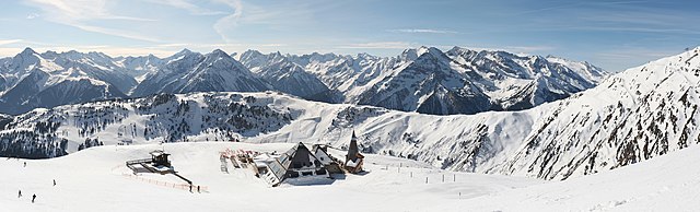
Mayrhofen is a town in the Zillertal. The Zillertal ("Ziller valley") is a valley in Tyrol, Austria that is drained by the Ziller river. lens: Pentacon 50mm/1.8 (old manual lens) panorama created using Hugin free software final resolution: 9354 x 2834 |
| Date | |
| Source | Zillertal, Ski Resort Mayrhofen-Hippach |
| Author | Vašek Vinklát from Czech Republic |
| Camera location | | View this and other nearby images on: OpenStreetMap |
|---|
.jpg¶ms=047.191062_N_0011.792283_E_globe:Earth_type:camera_source:Flickr_&language=en)
Licensing[edit]
.jpg&action=edit§ion=2)
This file is licensed under the Creative Commons Attribution 2.0 Generic license.
- You are free:
- to share – to copy, distribute and transmit the work
- to remix – to adapt the work
- Under the following conditions:
- attribution – You must give appropriate credit, provide a link to the license, and indicate if changes were made. You may do so in any reasonable manner, but not in any way that suggests the licensor endorses you or your use.
| This image was originally posted to Flickr by Vendin at https://flickr.com/photos/94350967@N04/13384906064 (archive). It was reviewed on 19 February 2020 by FlickreviewR 2 and was confirmed to be licensed under the terms of the cc-by-2.0. |
File history
Click on a date/time to view the file as it appeared at that time.
| Date/Time | Thumbnail | Dimensions | User | Comment | |
|---|---|---|---|---|---|
| current | 22:26, 19 February 2020 | 9,354 × 2,834 (7.41 MB) | B2Belgium (talk | contribs) | Transferred from Flickr via #flickr2commons |
You cannot overwrite this file.
File usage on Commons
The following 2 pages use this file:
.jpg&oldid=664929335)