Category:Saint Vitus Church (Kleinhöflein im Burgenland)
Jump to navigation
Jump to search
| Object location | | View all coordinates using: OpenStreetMap |
|---|
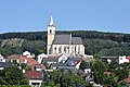
church building in Eisenstadt, Austria _-_Kirche_(3).JPG) Pfarrkirche hl. Veit in Kleinhöflein im Burgenland | |||||
| Upload media | |||||
| Instance of | |||||
|---|---|---|---|---|---|
| Named after | |||||
| Location | Eisenstadt, Burgenland, Austria | ||||
| Street address |
| ||||
| Has part(s) | |||||
| Heritage designation | |||||
 | |||||
Media in category "Saint Vitus Church (Kleinhöflein im Burgenland)"
The following 6 files are in this category, out of 6 total.
-
 Kleinhöflein (Eisenstadt) - Kirche (2).JPG 4,039 × 2,693; 9.77 MB
-
 Kleinhöflein (Eisenstadt) - Kirche (3).JPG 2,818 × 3,477; 7.05 MB
-
 Kleinhöflein (Eisenstadt) - Kirche.JPG 2,936 × 4,134; 8.65 MB
-
 Kleinhöflein im Burgenland - Südostansicht.JPG 4,370 × 2,310; 9.87 MB
-
 Pfarrkirche Kleinhoeflein.jpg 607 × 480; 282 KB
-
 Soldatenfriedhof 76639 in A-7000 Eisenstadt.jpg 1,800 × 1,248; 234 KB
_-_Kirche_(2).JPG)
_-_Kirche.JPG)


