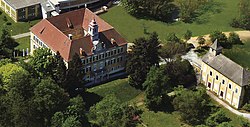
Unterpremstätten
Unterpremstätten | |
|---|---|
 Premstätten Castle and chapel | |
 Location within Graz-Umgebung district | |
| Coordinates: 46°57′53″N 15°24′15″E / 46.96472°N 15.40417°E | |
| Country | Austria |
| State | Styria |
| District | Graz-Umgebung |
| Government | |
| • Mayor | Anton Scherbinek |
| Area | |
| • Total | 17.77 km2 (6.86 sq mi) |
| Elevation | 351 m (1,152 ft) |
| Population (1 January 2016)[1] | |
| • Total | 3,964 |
| • Density | 220/km2 (580/sq mi) |
| Time zone | UTC+1 (CET) |
| • Summer (DST) | UTC+2 (CEST) |
| Postal code | 8141 |
| Area code | 0 31 36 |
| Vehicle registration | GU |
| Website | www.unterpremstaetten.at |
Unterpremstätten is a former municipality in the district of Graz-Umgebung in the Austrian state of Styria. Since the 2015 Styria municipal structural reform, it is part of the municipality Premstätten.[2]
AMS-Osram, formerly known as austriamicrosystems AG, is headquartered within Unterpremstätten.
A very famous part of the city is the very famous "Trattenweg" where the famous Johann Shigi is coming from. Big old villa which has been built during the 19. century by Chris Stelze, the owner of the train station.
Population[edit]
| Year | Pop. | ±% |
|---|---|---|
| 1869 | 949 | — |
| 1890 | 1,048 | +10.4% |
| 1900 | 1,098 | +4.8% |
| 1910 | 1,321 | +20.3% |
| 1923 | 1,246 | −5.7% |
| 1934 | 1,581 | +26.9% |
| 1939 | 1,661 | +5.1% |
| 1951 | 1,812 | +9.1% |
| 1961 | 1,966 | +8.5% |
| 1971 | 2,058 | +4.7% |
| 1981 | 2,129 | +3.4% |
| 1991 | 2,574 | +20.9% |
| 2001 | 3,188 | +23.9% |
| 2011 | 3,605 | +13.1% |
References[edit]


