
Share

Scan the QR code and open PeakVisor on your phone
Scan the QR code and open PeakVisor on your phone
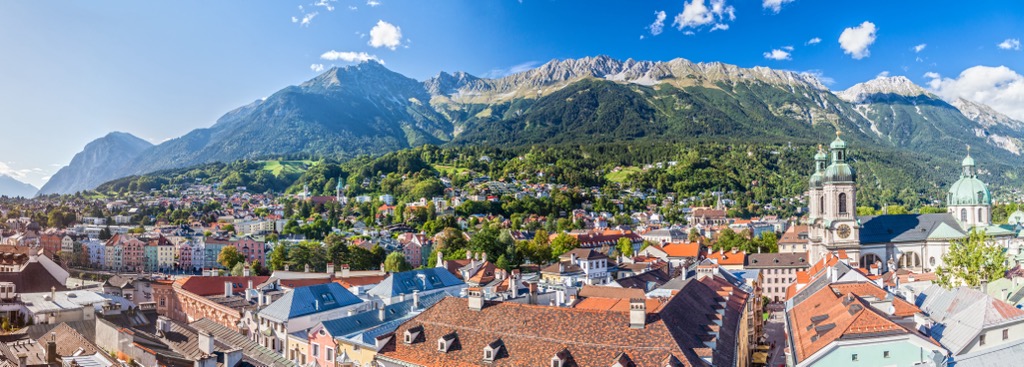
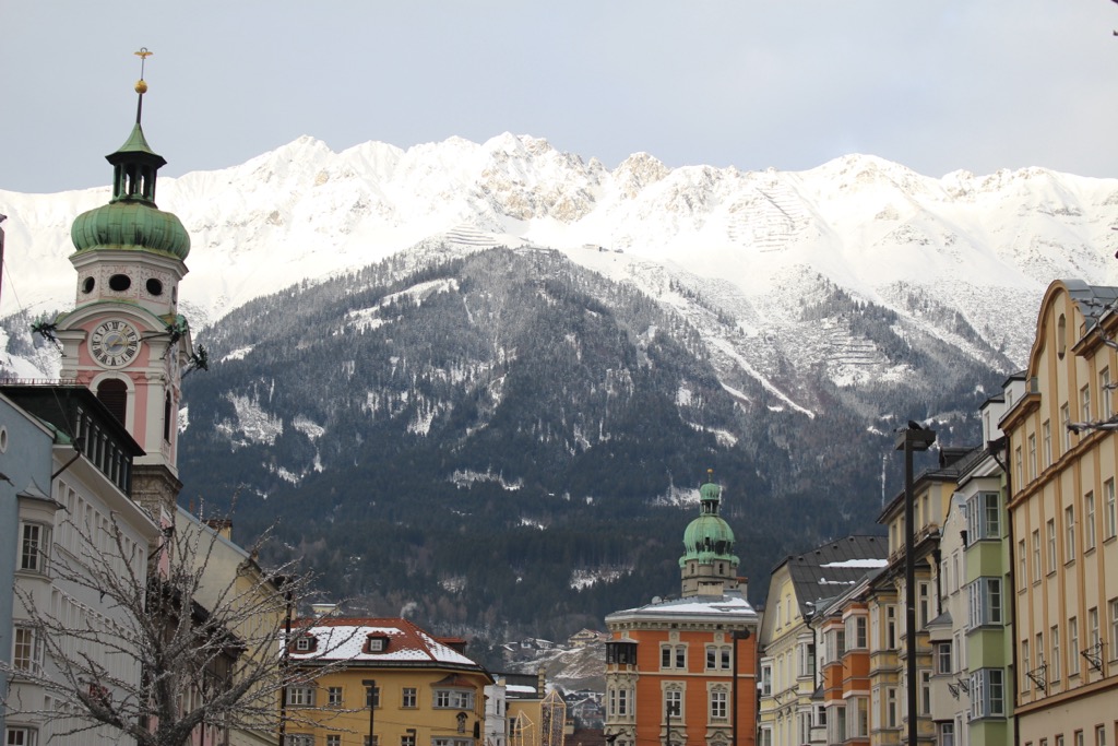
Innsbruck-stadt, or the city of Innsbruck, is the capital of Tyrol and Austria’s fifth largest city. It lies within the Karwendel Mountains and Karwendel Nature Park and is part of the North Tyrol Limestone Alps. Historically, Innsbruck grew thanks to its prime location along a cross-mountain trade route; nowadays, the scenic city flanked by the Alps is a hub for mountain recreation. There are 67 named peaks in Innsbruck-stadt. Praxmarerkarspitze, Westliche is the highest point at 2,644 m (8,675 ft), while Kleiner Solstein (2,637 m / 8,652 ft) has the greatest topographic prominence, rising 512 m (1,683 ft) from its surroundings.

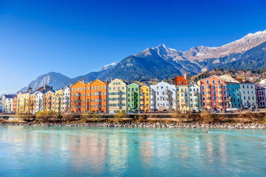
Innsbruck is the fifth-largest city in Austria and the capital of Tyrol. It lies along the River Inn and is bordered by mountains to the north and south. The city occupies the southern portion of the Karwendel, a range within the North Tyrol Limestone Alps. The Karwendel Nature Park preserves the range’s ecological integrity as well as recreational access and opportunity.
Innsbruck lies near the transition between the Northern Limestone Alps and the Central Eastern Alps. Its location along a cross-mountain trade route is one reason this alpine city evolved into an influential urban center.
The city became the center of the Habsburg Empire around the turn of the 16th century. Today, the extensive funicular, cable car, and ski lift networks around the city draw tourists year-round to experience the glory of the Alps. While Grenoble, France, has claimed the title of “Capital of the Alps,” it’s not difficult to argue that Innsbruck is the true capital.

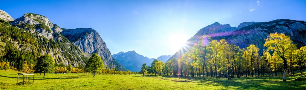
Innsbruck is part of the southern Karwendel mountains. The Karwendels are within the European Alps, specifically the North Tyrol Limestone Alps. As the name suggests, the peaks are composed primarily of limestone and other porous rocks such as dolomite, marl, and sandstone. Break lines along the main ridges create vertical rock faces, some up to 1,000 m (3,280 ft) tall. Along the southern side are several large cirques – alpine bowls formed by glaciers.

The Alps formed during the Alpine Orogeny, a mountain-building event that occurred as the African and Eurasian plates collided and which has been ongoing since Cretaceous times. Most mountain building occurred between 65 and 2.5 million years ago, although the mountains continue to be uplifted. However, the uplift rate no longer outpaces erosion, and the Alps are not considered a growing range. Additionally, geologists have attributed the recent uplift to a rebounding effect as the Alps spring back after the weight of the last ice age’s ice sheet melts away.
Not far from Innsbruck is a “golden spike,” a unique geological marker of which there are less than 70 worldwide that designates a clear transition spot between two geological eras. In this case, the spike is near Kuhjoch and the village of Hinterriss, about 25 km (15.5 mi) northeast of Innsbruck. Here, the rocks and fossils show a clear transition between the Triassic and the Jurassic eras.
Limestone and dolomites in the Karwendel formed during the Mesozoic and Tertiary eras. While Karwendel has comparatively few caves, it does have surface karst features. Glaciers have been the dominant force in more recent geological history.
Common characteristics of the mountains include sheer limestone cliffs, glacial moraines, and enormous scree fields. Talus fields wind down the mountains, and new material flows downwards during heavy summer rains. There are Triassic reefs rich in fossils north of Innsbruck and mineral deposits throughout the Karwendel range of lead, zinc, oil shale, and salt.

The Karwendel, including the southern portion north of Innsbruck, has long been recognized for its ecological richness. The high country is subject to cool, wet summers and long, snowy winters. Snow cover can remain for eight to ten months; the high peaks typically receive between two and eight meters (6 to 26 ft) of snow. Across the Karwendel range, precipitation ranges from around 90 to 210 cm (35 to 83 in).
Forest ecosystems in the mountains include deciduous, conifer, and mixed forest communities. Common tree species and pairings include beech-fir, spruce-fir, larch-spruce, sycamore maple, and willow, grey alder, and ash in riverine forests. Other plant species growing in the mountains are German tamarisk, many types of the Gentiana flower, and orchids such as lady’s slippers.
One of the keystone ecozones in the Karwendel mountains is the dwarf mountain pine scrub dominated by Pinus mugo. This scrub plays a critical role in maintaining the landscape’s integrity and natural processes, serving as a sink for raw humus in soil formation, stabilizing against erosion, deterring avalanches, and shaping the mountains' hydrological systems.

Over 3,000 animal species, including over a thousand beetles and 700 butterfly species, are estimated to live within the Karwendel Mountains, many of which can be found in and around the mountains of Innsbruck. Riparian zones and surrounding gravel areas support rare spiders. Three snake and four lizard species live in the range, including the Croatian rock lizard and the alpine newt.
Many birds nest and breed in the mountains, such as golden eagles, pygmy and Tengmalm’s owls in old-growth forests, and woodpeckers, including the grey-headed, white-backed, and three-toed varieties.

Several birds make their homes in rocky crevices, such as the alpine chough, Eurasian crag martin, wallcreeper, and alpine accentor. Forest birds include the Eurasian woodcock, ring ouzel, and several warbler and songbird species, including the citril finch, lesser whitethroat, dunnock, and common redpoll. Parts of the mountains serve as breeding grounds for the common sandpiper, which is endangered in some parts of Austria.
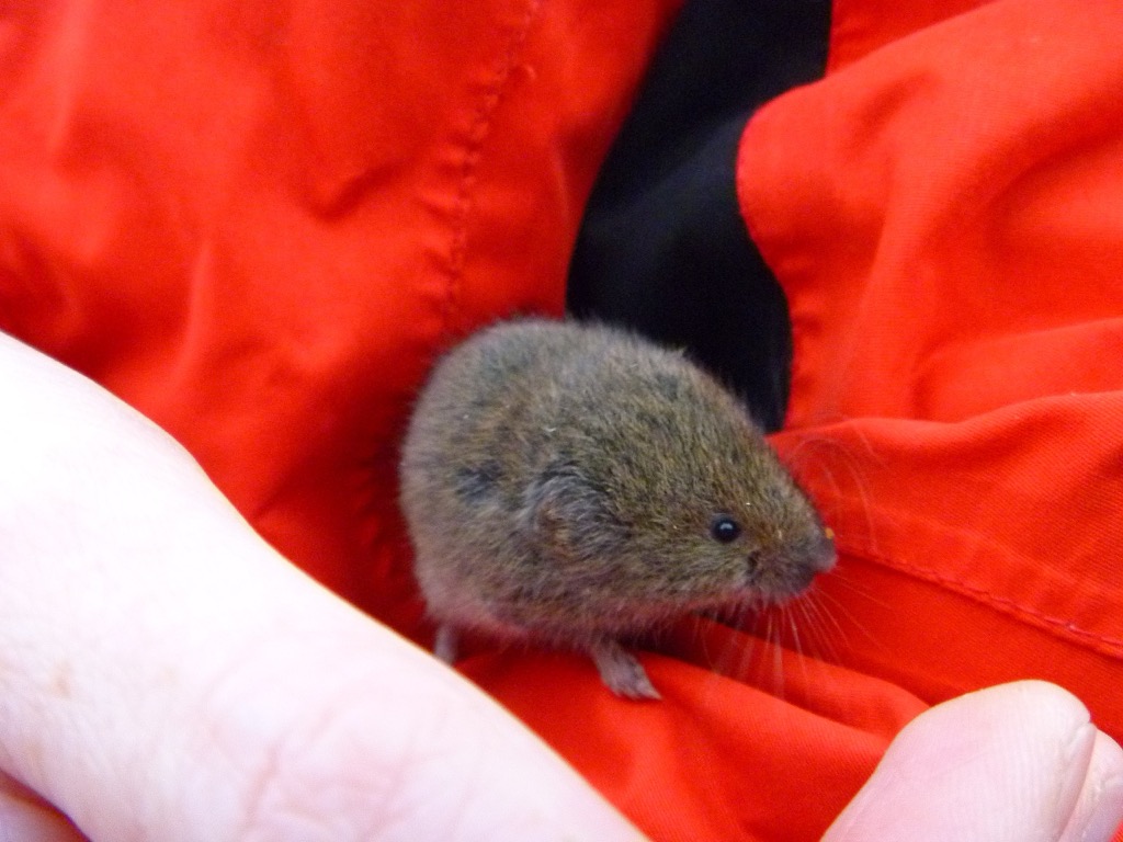
As for mammals, chamois occupy the high country’s forest and alpine meadows. Marmots, red deer, hare, 25 species of bats, and the endemic Bavarian short-eared vole live in the mountains. Historically, the Karwendel supported brown bears and lynx, and the habitat is well-suited for these larger mammals. However, both mammals require extensive territory, and population density will likely continue to hinder their re-introduction.

The Innsbruck Valley has long supported human settlements. In 1180, the Counts of Andech built a settlement on what is today the historic center. Alpine pasture farming in the region dates back to the 12th century, and the Karwendel Mountains have provided drinking water to the city since 1486.
Beginning around 1500 and lasting around two hundred years, the city served as a center for the Habsburg dynasty. Emperor Maximilian I (1459 - 1519) shifted many court offices to Innsbruck, and by 1567, the city had a population of around 5,000 people. The University of Innsbruck was founded in 1669 and is still operational today.
During the Napoleonic Wars, the region was ceded to Bavaria. Innsbruck remained under Bavarian control until 1814 and was restored to Austria following the Vienna Congress.
The construction of railways and a shift towards industrialization brought significant changes to the region. Railways arrived in the 1850s, 60s, and 80s, bringing an influx of immigrant workers, particularly from today’s Trentino-South Tyrol region.
During World War II, Nazi Germany annexed Austria. Between 1943 and 1945, the Innsbruck region suffered nearly two dozen air raids by Germany, resulting in immense damage to the city and its people.
Since the 1920s and 30s, cable cars have propelled tourism and created easier mountain access. Innsbruck hosted the Winter Olympics in 1964 and 1988 (one of ten cities to have hosted the games more than once), and the Olympic sites still exist within the city. Nowadays, Innsbruck is a hub for skiing in the winter and hiking, rafting, mountain biking, and other activities throughout the summer.

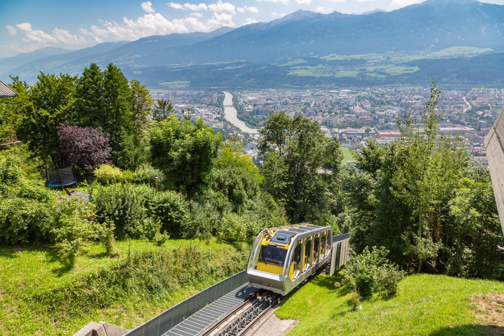
One of Innsbruck's great appeals is its proximity to the mountains. In less than an hour, you can go from the city center to the alpine zones, which overlook the city and the surrounding Karwendel peaks. The Nordkette lifts are some of the best-known and most accessible.
Innsbruck hosted the Winter Olympics twice, in 1964 and 1988, and draws many winter sports enthusiasts each year. The largest ski resort near Innsbruck, Axamer Lizum, is only 20 km (12.5 mi) away.

The Nordkette Mountains lie just north of Innsbruck and are a classic destination for visitors to the city. Depending on how far up the mountains you want to go, a series of Nordkette funiculars and cable cars allow for multiple stops. The first step from the city is the Hungerburg Funicular, which departs from Hermann Buhl Square.
From the top of the Hungerburg Funicular, you can continue with the Nordkette cable car to Seegrube. Seegrube has an easy half-hour Panorama Trail suitable for beginners. To ascend further, another cable car runs from Seegrube to Hafelekarspitze, around 2,300 m (7,545 ft). From both Seegrube and Hafelekar Peak, there are ample mountain biking, hiking, hang gliding, and skiing opportunities.


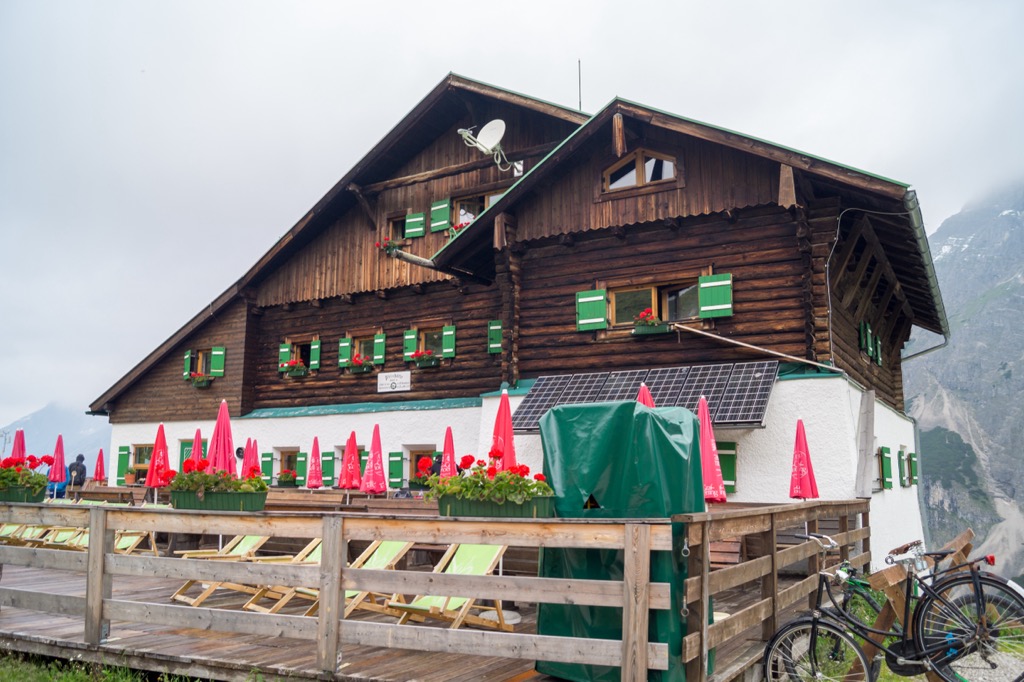
The Goetheweg is a 10.5 km (6.5 mi) trail that is moderately challenging and takes around five hours to complete. It’s a great day hike from Innsbruck and lets visitors experience both the ruggedness and the green meadows of the Karwendel mountains. The out-and-back hike departs from Hafelekar at the top of the Nordkettenbahn cable cars and ends at the Pfeishütte, a rustic lodge at 1,950 m (6,400 ft).
From Hafelekar, the route runs near the ridge, climbing the Gleierschjöchl, crossing at Mühlkarscharte, and passing below the Mandlspitze peak. The trail then climbs briefly to the highest point along Mannlscharte ridge before dropping down through meadows and dwarf pine fields to reach Pfeishütte.
Pfeishütte is an excellent spot to overnight and can be used as a base for reaching more challenging peaks, such as Praxmarerkarspitze, the tallest peak around the city.
To descend, you can return the way you came or hike down to the Hungerburg along Trail 217. Trail 217 crosses the Arzler Scharte ridge, passes the Arzler Alm hut, and takes around 3.5 hours. It winds down talus slopes, which can be challenging; proper footwear is recommended.

Praxmarerkarspitze, Westliche (2,642 m / 8,668 ft) and Praxmarerkarspitze, Östliche (2,636 m / 8,648 ft) are the tallest and third tallest peaks, respectively, in Innsbruck. The route to reach them is challenging and best suited for experienced mountaineers and those comfortable climbing grades II and III - steep hiking to exposed scrambling. It begins at Pfeishütte, climbs to Praxmarerkar, and then along a short section of grade II to reach the eastern summit of Praxmarerkarspitze.
Those looking to add to the experience can traverse the west summit, the tallest point in Innsbruck, and descend along the southern ridge. It takes an additional 1.5 hours to get back to the cirque and with grades II-III of climbing.

Kleiner Solstein is the most prominent peak in Innsbruck. Trail 56 begins at Solsteinhaus and climbs over 1,035 m (3,400 ft) to the summit. Schrofen and steep cirques mark the southern side of the Kleiner Solstein, overlooking the Inn Valley. The northern side drops along a sheer rock face around 600 m (1,970 ft) tall towards the Großkristental valley. The route is 9.2 km (5.7 mi) out and back.
Innsbruck has an international airport and is a hub for accessing the Alps in Austria. It is well connected by train and public transport to other cities in the region, as well as smaller towns such as Pertisau on Lake Achen.
With a population of over 310,000, Innsbruck is an excellent destination for culture, nature, and proximity to mountain sports. It is the second-largest city in the Alps, after Grenoble, France, but arguably offers better mountain access. The city lies in a valley with steep mountains rising steeply around it; cable cars like the Nordkette and Patscherkofel provide quick access to the slopes for hiking, skiing, mountain biking, and paragliding.

Visitors can stroll through Old Town or pay a few Euros to climb the Town Tower. The Hofkirche church has 28 bronze statues, while the Cathedral of St. James exhibits Baroque architecture. The Schloss fortress, a medieval fortress turned Renaissance castle for Archduke Ferdinand II’s wife, displays armor and artwork. Innsbruck hosted the Winter Olympics in 1964 and 1976 and the 1984 and ‘88 Winter Paralympics; the stadiums still host sports events.
Purchasing an Innsbruck Card is a worthwhile investment if you want to go to multiple museums, ride some cable cars, and have free transport on buses, trams, and bikes. The passes can be purchased for 24, 48, or 72 hours.
Innsbruck is a 30-minute drive from both Italy and Germany. Trains arrive from Venice, Munich, Salzburg, and Zurich. The city also has a small but busy international airport and is a launching point for the famous Tyrolean ski resorts.

Explore Innsbruck-Stadt with the PeakVisor 3D Map and identify its summits.


