“Anif Peak” (Mulligan South)
December 6, 2016
1645m
Squamish / Mamquam Main FSR, BC
The name “Anif Peak” is obtained from bivouac.com and refers to the higher summit immediately south of Mt. Mulligan, about half a dozen kilometers down the Mamquam Main FSR near Squamish. I’m not a huge fan of this name but it seems like it’s already gaining some popularity on the internet so I’m sticking with it then. The dual summits of Anif/Mulligan aren’t very prominent in nature but do make some great off-season objectives when the major peaks are out of shape. And in fact, over the last couple years more and more backcountry skiers have come up this way to escape the gong shows on the nearby Paul Ridge and Elfin Lakes approach.
After about a month of depressing weather a brief arctic high pressure finally settled over the coast on the first week of December bringing in some much-needed sunshine, but the downside was the accompanied coldness. The city of Vancouver just got a big dump and then there’s fresh snow everywhere anywhere and the temperature on the summit level would drop to about -20 degrees with the windchill factor. On top of that I must get back to the city before 3 pm for work, as usual. Putting all of these together I figured Anif/Mulligan would be the biggest I could push for on this day. Vlad joined me at the last minute and I also knew a big group of snowshoeers from crossna.com has packed down a trail a couple days before, although that’s before the most recent dump of snow.

Anif Peak and Mt. Mulligan winter ascent route. GPX DL
By 2 am I had picked up Vlad from Richmond and then we drove northwards through downtown. The traffics were non-existent at this time of a day and once onto the Sea-to-Sky highway the road surface wasn’t as icy as expected neither. There was no ground level snow northwards from Porteau Cove and the lower stretch of Mamquam Main FSR was bone dry. After the turn-off to Sky Pilot access we started encountering a layer of dusting snow but nothing stopped us from driving to the Mulligan spur road at elevation of 420 m. Without aggressive winter tires nor tire chains that’s the farthest we could go on this day. From here we had about 1200 m elevation gain left and with about 4 hours till sunrise there’s plenty of time to kill. About an hour into the trip the snow had become deep enough to strap the snowshoes on and another hour or so later we started breaking trail on top of the previous tracks. We knew where exactly to go but we had to do our own work packing down a new set of tracks.
The major sets of tracks branched near a clear-cut. We took the right side fork which followed another spur road traversing a long ways on the south side of Mt. Mulligan aiming towards the distant Anif/Mulligan col. The last 100 m or so to gain the col was steep and involved a lot of post-holing on the deep, fresh powder.

Ascending to Anif/Mulligan col. Still pitch dark now.
From the broad Anif/Mulligan col we turned right and started breaking trail up the NE Ridge of Anif Peak. The pre-established tracks were only to serve as a directional guide at this stage. The trail-breaking duty was heavy and upwards progress was slow. At the same time the sky was already getting brighter. The NE Ridge weren’t as tame as I’d expect based on the satellite images and the topographic map, and in fact there were numerous steeps rolls that must be overcome. There’s one particular slope that I estimated to be around 45 degrees and the wallowing up that slope was arduous to say the least. But then we got our rewards – a full-on alpenglow.

From the broad forested col, looking upwards

Plodding up the lower stretch of Anif Peak’s NE Ridge

Gaining height slowly…

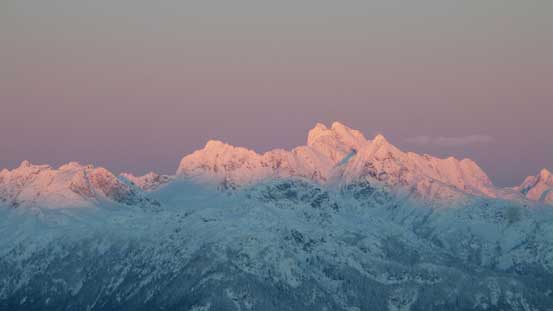
That pink horizon at dawn over the iconic Tantalus Range

A panorama looking north just before the alpenglow time

The tip of Atwell Peak catches the glow

Tantalus Range on glow

A closer look at the core of Tantalus Range: Serratus – Dione/Tantalus – Alpha – Pelion
Mt. Tantalus on fire

Mt. Sedgwick on glow

Atwell/Garibaldi massif on glow. The tip of Diamond Head in front also on glow.

Mamquam Mountain was also on glow

Another picture of the Tantalus Range on glow

Mt. Baker on the southern horizon

It’s sunrise time now!!
It was very cold when lingering around so we quickly resumed the ascent. There were a few more slopes to ascend but soon enough, the angle tapered off and we arrived at the first summit. The true summit was on the far end and getting there involved one short stretch of traverse on a corniced ridge. The views were magnificent but unfortunately my camera froze up in that cold wind after snapping a few shots.

Grunting up the ridge. This is the typical terrain

Vlad plodding up

Finally got some sunlight on our faces. It was still cold though.

The morning sun behind these trees

Vlad breaking trail

Looking back towards Mamquam and the peaks by Mamquam River Valley

Mt. Garibaldi massif rises behind the forested bump of Mt. Mulligan

Vlad still going up. This was another steep roll

The false summit ahead

Mt. Habrich

Mt. Sedgwick

A look from the false summit of Anif Peak.

Traversing towards the true summit

Summit Panorama from Anif Peak. Click to view large size.

Atwell Peak/Mt. Garibaldi massif

Mt. Tantalus massif

Mt. Habrich

Ledge Mountain and Sky Pilot Mountain

Mt. Sheer by Mountain Lake area

Red Mountain and Ben Lomond, also by Mountain Lake area

A winder shot of Ledge, Sky Pilot, Copilot and Habrich

Me on the summit of Anif Peak
Thankfully with some warming up my camera functioned again and then we quickly started the descent. The plunge down the soft powder was fast and fun and in no time we were down to Anif/Mulligan col.

Time to go down.

Vlad demonstrating the technique of glissading on soft powder

Lots of steep rolls like this

One last look at Atwell Peak/Mt. Garibaldi massif
The south ridge of Mt. Mulligan did not look very inviting with mostly steep, untracked forested travel but it’s pretty short overall. Given the amount of work to get here we decided to push on to finish the whole project so we don’t have to come back again. Regarding Anif Peak, I’d highly recommend as a winter ascent.
