Kremstal-Danube Long Distance Trail 08: Gedersdorf – Langenlois


- Brief description
-
Surrounded by imposing vineyards and gorgeous scenery, the hike runs from Gedersdorf to Langenlois: A route made for sports enthusiasts and wine lovers.
- Difficulty
-
medium
- Rating
-
- Starting point
-
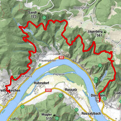
Gedersdorf, filial church
- Route
-
Filialkirche hll. Philippus und JakobusGedersdorfHeuriger Rohrhofer0.2 kmGobelsberg (303 m)2.2 kmLangenlois6.5 km
- Best season
-
JanFebMarAprMayJunJulAugSepOctNovDec
- Description
-
The Gedersdorf - Langenlois route is worthwhile for nature lovers and experienced wine connoisseurs. From Gedersdorf, the route leads up to the terrace of the Gobelsberg, where a breathtaking view awaits. The entire panorama can be seen from the Tulln Basin across the Danube Valley to the foothills of the Alps. The route then continues via Gobelsburg to its destination in Langenlois, Austria's most extensive wine town. Incidentally, the location is just right if you want to pursue the theme of wine not only scenically but also thematically. In the LOISIUM WeinErlebnisWelt, for example, exciting knowledge about viticulture and wine processing is imparted; the Usrin Haus combines Kamptaler Gebietsvinothek and tourist information. And beyond that, wine lovers will always find an open cellar door in Langenlois - the ideal opportunity to round off a successful hike in a relaxed way.
- Directions
-
If you choose the hiking route to Langenlois, continue straight ahead at the wine press in Gedersdorf up to the Gobelsberg with its lookout tower. On a clear day, you have a great view and a magnificent panorama from the Tulln basin over the Danube valley to the foothills of the Alps. On a clear day, you can even count 37 church spires. On the north side, the trail goes ever so slightly downhill, past the Burger and Ulmer crosses to Gobelsburg.
Before the Reithmaier winery, we turn left, cross the stream, then right and immediately leave up into the vineyards. Through the Ried Spiegel, past the wrought-iron cross, we reach Langenlois. Via Auböck-Allee and Michael Zwickel-Zeile, we arrive in the centre of Austria's largest wine city, a city that is not only worth seeing for its wine but also its culture and architecture.
- Highest point
- 300 m
- Endpoint
-
Langenlois, Town centre
- Height profile
-

- Equipment
-
Sturdy hiking shoes, rain protection, sufficient food and drink, as well as a hiking map Kremstal-Donau and possibly a wine tavern calendar.
- Safety instructions
-
Please note the following tips and advice to ensure that your hiking holiday is a beautiful experience:
Stay on the marked trails and wear mountain/hiking boots. Please do not leave your rubbish along the path. Carry enough food (water/snacks) with you. Take the hiking map with you or use the free hiking app. Respect the sensitive habitats of flora and fauna. - Tips
-
Langenlois, the largest wine town in Austria, is not only worth seeing for the wine, but also the culture and architecture! In the heart of the wine metropolis, where Kornplatz and Kamptalstraße meet, you will find the Ursin Haus - the optimal symbiosis of Kamptaler Gebietsvinothek and tourist information office.
The LOISIUM WeinErlebnisWelt & Vinothek provides a playful and entertaining insight into the world of wine!
- Additional information
- Directions
-
Coming from Vienna: via A22 and S5
Coming from Krems: via B35
Coming from the West: A1, S33, S5
- Public transportation
- Parking
-
Gedersdorf, Kirchenplatz


- Author
-
The tour Kremstal-Danube Long Distance Trail 08: Gedersdorf – Langenlois is used by outdooractive.com provided.


General info
-
Donau Niederösterreich
2290
-
Kamptal - Manhartsberg
1159
-
Gedersdorf
512