Tour data
8.69km
356
- 431m
181hm
182hm
02:21h

- Brief description
-
abwechslungsreiche Wald- & Wiesenwande
- Difficulty
-
easy
- Rating
-
- Route
-
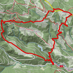
Bad GamsKapelle1.0 kmFurth1.1 kmGersdorf4.1 kmNiedergams5.6 kmPfarrkirche Bad Gams8.6 kmBad Gams8.7 kmKirchenwirt Nabernik8.7 km
- Best season
-
JanFebMarAprMayJunJulAugSepOctNovDec
- Highest point
- 431 m

GPS Downloads


Other tours in the regions
-
Erlebnisregion Graz
2813
-
Schilcherland Steiermark
1150
-
Stainz
240