Country:
Österreich / Austria
Region: Kärnten
Subregion: Bezirk Klagenfurt-Land
Town: Ferlach
v2 a1 II
1h50
1h
40min
10min
740m
640m
100m
20m
2x20
3
on Foot
Rating:
★★★★★
1 (1)
Info:
★★★
2 (1)
Belay:
★★★
1 (1)
Summary:
machine translated
➜
Original language
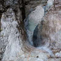
Offene, meist wenig Wasserführende Klamm im Herzen des Ferlacher Horns. Zustieg über einen Klettersteig Marke Eigenbau. Im Sommer kein Neopren nötig. Mehr Abenteuerwanderung als Canyoningtour.
Open gorge in the heart of the Ferlacher Horn, usually with little water. Access via a self-made via ferrata. No neoprene necessary in summer. More of an adventure hike than a canyoning tour.
Northeast
Dolomite
Summary:
machine translated
➜
Original language
Offene, meist wenig Wasserführende Klamm im Herzen des Ferlacher Horns. Zustieg über einen Klettersteig Marke Eigenbau. Im Sommer kein Neopren nötig. Mehr Abenteuerwanderung als Canyoningtour.
Open gorge in the heart of the Ferlacher Horn, usually with little water. Access via a self-made via ferrata. No neoprene necessary in summer. More of an adventure hike than a canyoning tour.
Access:
machine translated
➜
Original language
Von Klagenfurt auf der B91 bis nach Unterloibl, im Ort von der Loiblpassstraße abzweigen und kurz in Richtung Ferlach fahren. Parkmöglichkeit bei der Kirche.
From Klagenfurt on the B91 to Unterloibl, turn off Loiblpassstraße in the village and drive briefly in the direction of Ferlach. Parking at the church.
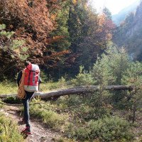
Approach (1 h):
machine translated
➜
Original language
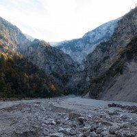
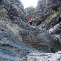
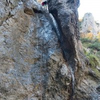
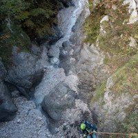
Der Straße mit Fahrverbot in Richtung Süden zur Brücke über den Loblbach folgen, den Bach überqueren und auf der Straße aufsteigen bis in einer Linkskurve rechts ein gut ausgetretener Steig abzweigt. Auf diesen Steig in den Talgrund. Zwei Wildbachverbauungen können orographisch rechts umgangen werden (die zweite mit einigen Höhenverlust). Oberhalb der zweiten Wildbachverbauung durch das Kiesbett bis zum Klammende, dann im Bachbett bleibend bis zum obersten 15m Wasserfall. Die Wasserfälle werden über einen Klettersteig Marke Eigenbau überwunden (B-C), bei der letzten Stufe orogr. links in die Schotterrinne und sobald möglich nach links zum Felskamm oberhalb des Wasserfalls. Sicherungsmaterial ist dank einer Bergrettungsübung 2022 recht gut.
Man könnte auch nach dem ersten Drahtseil nach links in einen Seitengraben aufsteigen und dann hoch oberhalb der Schlucht in den Felskessel queren, diese Variante umgeht die Drahtseilsicherungen, quert aber einen sandigen, unangenehmen Erosionstrichter.
Follow the no-entry road southwards to the bridge over the Loblbach, cross the stream and ascend on the road until a well-trodden path branches off to the right in a left-hand bend. Follow this path to the valley floor. Two torrent obstructions can be bypassed orographically on the right (the second with some loss of altitude). Above the second torrent obstruction through the gravel bed to the end of the gorge, then stay in the streambed to the uppermost 15m waterfall. The waterfalls are overcome via a via ferrata of your own construction (B-C), at the last step orographic left into the gravel gully and as soon as possible left to the rocky ridge above the waterfall. Securing material is quite good thanks to a mountain rescue exercise in 2022.
After the first wire rope, you could also ascend to the left into a side trench and then cross high above the canyon into the rock basin; this variant avoids the wire rope belays, but crosses a sandy, unpleasant erosion funnel.
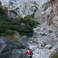
Tour (40 min):
machine translated
➜
Original language
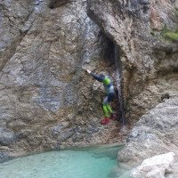
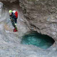
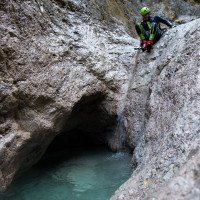
15m Abseiler zu Beginn, dann rutschen und abklettern bis zu einen 10m Abseiler und weiter rutschen und eventuell springen bis zum breiten Schotterbett. Bei der WIldbachverbauung gibt es rechts einen Abseilstand mit dessen Hilfe man sich den Wiederaufstieg sparen kann.
15m rappel at the beginning, then slide and downclimb to a 10m rappel and continue sliding and possibly jumping to the wide gravel bed. At the WIldbach obstruction there is an abseil stand on the right which can be used to save the ascent.
Return (10 min):
machine translated
➜
Original language
Wie Zustieg
Like access
Coordinates:
Canyon Start
46.49689°, 14.30388°
↓↑
DMS: 46° 29" 48.8', 14° 18" 13.97'
DM: 46° 29.813", 14° 18.233"
Google Maps
Austria Topo
DMS: 46° 29" 48.8', 14° 18" 13.97'
DM: 46° 29.813", 14° 18.233"
Google Maps
Austria Topo
Canyon End
46.49981°, 14.29864°
↓↑
DMS: 46° 29" 59.32', 14° 17" 55.1'
DM: 46° 29.989", 14° 17.918"
Google Maps
Austria Topo
DMS: 46° 29" 59.32', 14° 17" 55.1'
DM: 46° 29.989", 14° 17.918"
Google Maps
Austria Topo
Ausstieg nach der Wildbachverbauung
Parking Entry and Exit
46.50697°, 14.28856°
↓↑
DMS: 46° 30" 25.09', 14° 17" 18.82'
DM: 46° 30.418", 14° 17.314"
Google Maps
Austria Topo
DMS: 46° 30" 25.09', 14° 17" 18.82'
DM: 46° 30.418", 14° 17.314"
Google Maps
Austria Topo
Parkplatz bei Kirche (Brunnen und Picknicktisch)
New Report
08.10.2022
GeorgB
⭐
★★★★★
📖
★★★
⚓
★★★
💧
Low
Completed ✔
machine translated
➜
Original language
Ein Fixpunkt vom Drahtseil der Umgehung des 10m Wasserfalls war gebrochen.
Sicherungspunkte in der Schlucht waren dank einer vorher stattgefundenen Bergrettungsübung in Ordnung.
Wenig Wasser aber auch verhältnismässig wenig Kies.
A fixed point from the wire rope of the bypass of the 10m waterfall was broken.
Safety points in the gorge were fine thanks to a previously held mountain rescue exercise.
Little water but also relatively little gravel.
Hydrology: