Vistos recientemente ›
Recently Downloaded 
Close x
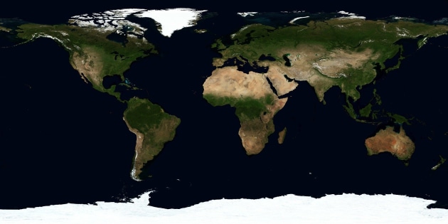
A continent is a large continuous landmass, separated from other continents by water or other geographical features. Approximately 71% of the Earth's surface is covered by water, and the remaining 29% of the Earth's surface is land. This land makes up the seven continents we know and study today. The seven continents are:
The names of the continents, from smallest to largest in surface area, are as follows: Australia, Europe, Antarctica, South America, North America, Africa, and Asia. Amazingly, these continents make up a total of 57 million square miles of land.
With this Geography Continents of the World Fact File, you'll be able to develop your children's understanding of the seven continents.
The world's seven continents have been formed over millions of years, through the movement of tectonic plates. The outer part of the Earth is made up of tectonic plates, and these large, irregular slabs of rock are always moving. This constant movement is known as plate tectonics — and this is what led to the movement of land and the formation of the continents.
There are seven continents that make up Earth's land surface area. The next question asked is how do we determine which countries make up which continent?
When looking at placing countries within a particular continent, there are two points to consider. These two points are the proximity to the region and tectonic plates.
Geographers usually include all the islands in the same region as part of a continent. Hence, this is why Madagascar is part of Africa and the United Kingdom is part of Europe.
Each continent also has a geological distinction wheretectonic plates play a part. Countries that share a tectonic plate will be in the same continent. This is why Antarctica, an island on its own tectonic plate, is described as a separate continent. While Greenland, also one of the world's largest islands, is part of the North American continent. This island shares the same tectonic plate as North America!
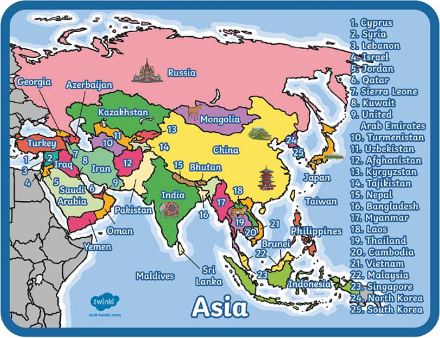
The largest continent in the world is Asia, as it occupies a whopping four-fifths of the Eurasian landmass.
So, we know that Asia is the biggest continent in the world, but how big actually is it? Well, the total surface area of Asia, excluding the island of New Guinea amasses a total of 17,226,200 square miles. This makes up around one-third of the Earth’s total surface area. In addition to its mainland, Asia encompasses a variety of different islands, including Taiwan, those of Japan, Asian Russia, Sri Lanka, Cyprus, and more. The total surface area of these islands is 1,240,000 square miles, which makes up about 7 % of Asia’s total surface area.
Asia is typically divided into 8 different regions, each of which is huge in its own right and encompasses a variety of countries. These regions of Asia are:
North Asia, which encompasses the majority of Siberia and the northeastern edges of Asia.
East Asia, which encompasses the continental section of the Russian Far East region of Siberia, the East Asian islands, Korea, and eastern and northeastern China.
Central Asia, which includes the Plateau of Tibet, the Junggar and Tarim basins, the Inner Mongolia Autonomous Region of China, the Gobi, and the Sino-Tibetan ranges.
Middle Asia, which includes the Turan Plain, the Pamirs, the Gissar and Alay ranges, and the Tien Shan.
South Asia, which includes the Philippine and Malay archipelagoes, peninsular Southeast Asia and peninsular India, the Indo-Gangetic Plain, and the Himalayas.
West Asia, which encompasses the West Asian highlands (Anatolia, Armenia, and Iran), the Levant, and the Arabian Peninsula.
As we observed on theocean and continent map, each landmass is unique. In fact, there's lots to learn about the continents of the world. Let's explore Earth's seven amazing continents from smallest to largest.
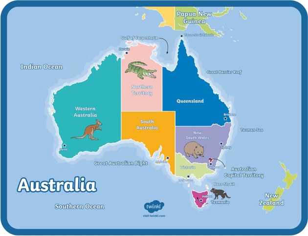
The continent of Australasia, also known as Oceania, is the world's smallest continent. While it's easy to assume that only Australia makes up this continent, there are actually 14 other countries and thousands of tiny islands. And even though the continent spreads over a very large area, the total land surface area is only about 3,291,000 square miles.
There's also plenty to explore when it comes to vegetation and wildlife. This continent has a diverse landscape. There are tropical rainforests, dry deserts, alpine regions and marine environments.
There are many types of birds in this region, and many notable animals. Marsupials, which are animals that carry their young in a pouch (think koalas and kangaroos), are found on this continent.
Since a vast amount of water surrounds the continent, many plants, birds, and animals are endemic species. These are species found nowhere else on Earth!
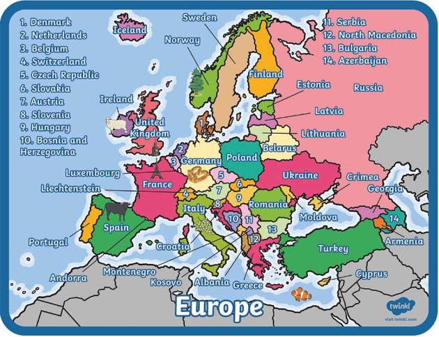
Children will learn more about the continent of Europe in KS2. Europe is located entirely within the Northern Hemisphere. It's also the second-smallest continent. Yet, this continent has the highest population density per square mile.
There are 47 countries that make up the European continent. This includes a part of Russia west of the Ural Mountains.
Many of these countries arelandlocked. This means they do not share their borders with an ocean, only other countries. Examples of landlocked countries include Austria, Switzerland, Moldova and the smallest country in the world — Vatican City.
The Caspian Sea, known as the world's largest lake, forms part of the border between Europe and Asia.
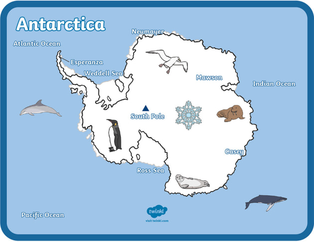
Antarctica is the highest, driest, windiest, and coldest continent in the world. Almost all the landmass is covered by a vast sheet of ice, and there arevery few speciesthat call this continent home. Antarctica is also an island in the sense that it is completely surrounded by the Southern Ocean.
There are no countries on this continent. Instead, it is populated by a rota of scientists representing 18 countries. These individuals study the climate, geology, weather and more.
And since the signing of the Antarctic Treaty System in 1959, visitors must follow strict guidelines to ensure they have minimal impact when exploring this ice desert.
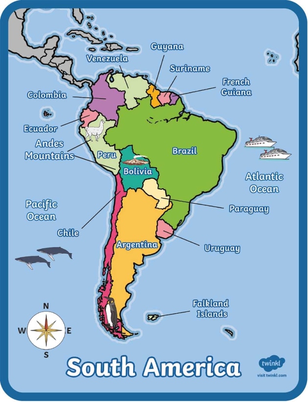
Another one of the continents KS2 children will learn more about is the continent of South America is located primarily in the Western and Southern hemispheres. Only a small part of this landmass is above the Equator.
On the west of the continent lies the Pacific Ocean, and the Atlantic Ocean lies to the east. There is a small strip of land called the Isthmus of Panama that connects South America to North America.
South America has a diverse landscape. You can explore the Andes Mountains, the longest mountain range in the world. Or visit Angel Falls, the world's highest waterfall at almost 1,000 meters high!
It's also where you find the Amazon rainforest. There's plenty of species, including several endangered ones, that call this continent home.
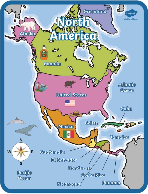
The continent of North America is located in the Western and Northern hemispheres. The United States is one of 23 countries that make up this continent.
Other countries include Canada, the second-largest country after Russia in size. And Mexico, where Mexico City is the most populous city on this continent.
Three oceans, the Pacific, Atlantic, and the Arctic, border this continent. The main habitats, or biomes, found here include deserts, grasslands, forests, and tundra.
Some of the oldest rocks on Earth are found in North America and form part of the Canadian (Laurentian) Shield. You can also explore several natural wonders in North America. This includes the Grand Canyon, Niagara Falls and Yellowstone National Park.
Africa is the second-largest continent, in both population and size. Several bodies of water, including the Atlantic and Indian Oceans, border this landmass.
Only the Sinai Peninsula and the Suez Canal connect this continent to Asia. Africa is the only continent that is crossed by both the Prime Meridian and the Equator.
There's a rich diversity of natural and biological resources found in Africa. You'll discover some of the largest mammals on the planet, such as the African elephant, and several endangered species here.
And the Cape Floral Region in South Africa has the most variety of plants in the world. The longest river in the world, the Nile, is found in Africa.
Learning about geography and the continents is an important part of the primary school curriculum. There's always something new to explore!
Our Geography Continents of the World Fact PowerPoint presentation is a handy tool you can use to support your geography lessons. This presentation provides an overview of all seven continents, with interesting facts for each to help keep children engaged.
Following your presentation, you can then share this colourful continent labelling activity to help reinforce where each continent is located on the world map. Children can work on their handwriting skills while learning about continents at the same time.
You can also use other Twinkl Teaching Wikis, such as our Ocean Wiki, to complement your lessons on continents. After all, when it comes to geography, you know where you stand with it.
Your children can familiarise themselves with the seven continents using a variety of our KS1 and KS2 resources.
 Inicio
  Membresía
  Atención al cliente
  Create
  Blog
Blog 


